
Maxwell, Pressley Cove(s) loop
Moderate 5 mile loop hike with roughly 1,000 feet of elevation gain through the Ranger District section of Pisgah National Forest. A community-led outing focused on steady climbing, trail time, and mountain scenery.
Similar Events

Moderate-paced Mountains-to-Sea Trail hike on a narrow, undulating route with rocky steps early and a rooty tread most of the way, plus a short climb around the 2.5-mile mark. Leashed, well-behaved dogs welcome for a fitness-focused group outing from the Craven Gap gravel lot.
Moderate-paced Mountains-to-Sea Trail hike on a narrow, undulating route with rocky steps early and a rooty tread most of the way, plus a short climb around the 2.5-mile mark. Leashed, well-behaved dogs welcome for a fitness-focused group outing from the Craven Gap gravel lot.
Moderate-paced Mountains-to-Sea Trail hike on a narrow, undulating route with rocky steps early and a rooty tread most of the way, plus a short climb around the 2.5-mile mark. Leashed, well-behaved dogs welcome for a fitness-focused group outing from the Craven Gap gravel lot.
A moderate-paced group hike covering 5–5.5 miles from the Rice Pinnacle parking area in Bent Creek. Expect a steady 2.7–3 mph walk with a single halfway water stop and a finish around 10:50–11:00 p.m.
A moderate-paced group hike covering 5–5.5 miles from the Rice Pinnacle parking area in Bent Creek. Expect a steady 2.7–3 mph walk with a single halfway water stop and a finish around 10:50–11:00 p.m.
A moderate-paced group hike covering 5–5.5 miles from the Rice Pinnacle parking area in Bent Creek. Expect a steady 2.7–3 mph walk with a single halfway water stop and a finish around 10:50–11:00 p.m.

A moderate 5-mile out-and-back on the Mountain-to-Sea Trail from Craven Gap, crossing the Parkway and rolling through newly reopened terrain reshaped by Hurricane Helene. Midpoint break at 2.5 miles before returning the same route.
A moderate 5-mile out-and-back on the Mountain-to-Sea Trail from Craven Gap, crossing the Parkway and rolling through newly reopened terrain reshaped by Hurricane Helene. Midpoint break at 2.5 miles before returning the same route.
A moderate 5-mile out-and-back on the Mountain-to-Sea Trail from Craven Gap, crossing the Parkway and rolling through newly reopened terrain reshaped by Hurricane Helene. Midpoint break at 2.5 miles before returning the same route.
Forest trails lead to mossy waterfall viewpoints on a guided midday hike, with interpretive trail commentary, steady paced walking, and panoramic creekside scenery, ideal for outdoors enthusiasts and photographers.
Forest trails lead to mossy waterfall viewpoints on a guided midday hike, with interpretive trail commentary, steady paced walking, and panoramic creekside scenery, ideal for outdoors enthusiasts and photographers.
Forest trails lead to mossy waterfall viewpoints on a guided midday hike, with interpretive trail commentary, steady paced walking, and panoramic creekside scenery, ideal for outdoors enthusiasts and photographers.

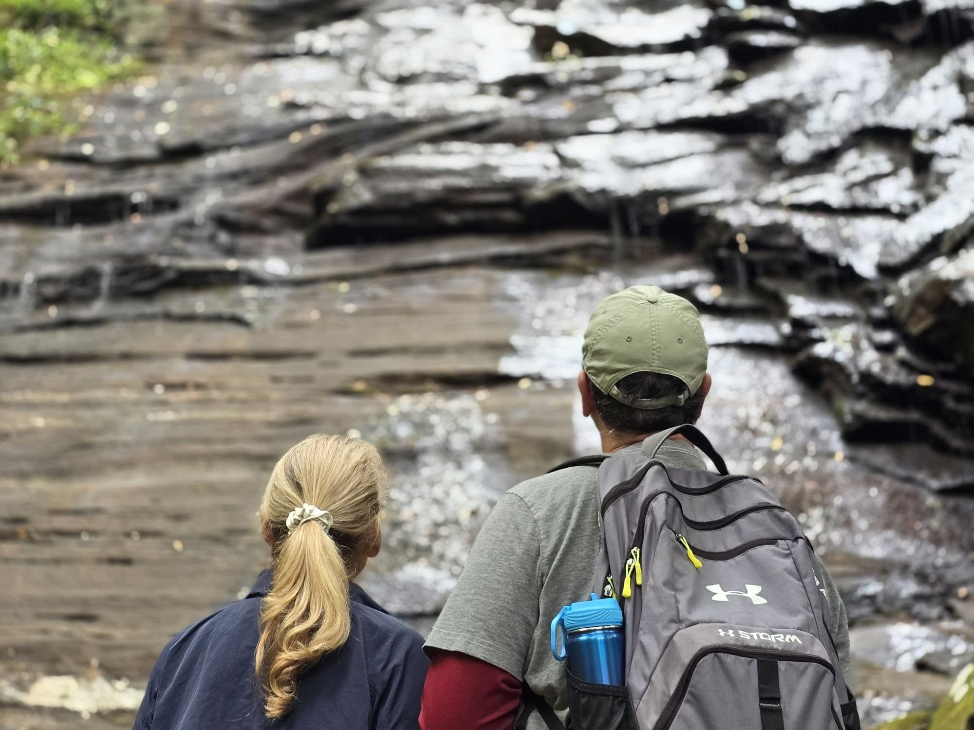
Group hike along shaded forest trails to Catawba Falls, passing moss covered rocks and cascading waterfall viewpoints; meet at 70 College Street for a relaxed, community paced daytime walk.
Group hike along shaded forest trails to Catawba Falls, passing moss covered rocks and cascading waterfall viewpoints; meet at 70 College Street for a relaxed, community paced daytime walk.
Group hike along shaded forest trails to Catawba Falls, passing moss covered rocks and cascading waterfall viewpoints; meet at 70 College Street for a relaxed, community paced daytime walk.

A brisk evening hike (~6.4 miles) through the hills east of downtown, passing Windswept Dr. and Helen’s Bridge with short regrouping breaks along the way. Meet at the Depot St. parking lot for a steady 2.5–3.0 mph pace, including uphill stretches.
A brisk evening hike (~6.4 miles) through the hills east of downtown, passing Windswept Dr. and Helen’s Bridge with short regrouping breaks along the way. Meet at the Depot St. parking lot for a steady 2.5–3.0 mph pace, including uphill stretches.
A brisk evening hike (~6.4 miles) through the hills east of downtown, passing Windswept Dr. and Helen’s Bridge with short regrouping breaks along the way. Meet at the Depot St. parking lot for a steady 2.5–3.0 mph pace, including uphill stretches.

A brisk 3.2 mile neighborhood walk from Sunset Park through the Albemarle Park historic district and up Cherokee Road, mixing gradual climbs with a few steep sections. Expect 604 ft elevation gain, ~2.8 mph pace, and mountain-view streetscapes.
A brisk 3.2 mile neighborhood walk from Sunset Park through the Albemarle Park historic district and up Cherokee Road, mixing gradual climbs with a few steep sections. Expect 604 ft elevation gain, ~2.8 mph pace, and mountain-view streetscapes.
A brisk 3.2 mile neighborhood walk from Sunset Park through the Albemarle Park historic district and up Cherokee Road, mixing gradual climbs with a few steep sections. Expect 604 ft elevation gain, ~2.8 mph pace, and mountain-view streetscapes.

An easy 4.5 mile Bent Creek loop from Ledford Branch Trailhead via Deer Lake Lodge and Ledford Branch Road, paced for a group meetup. Wrap up with a casual lunch hang at Griff's Kitchen after the hike.
An easy 4.5 mile Bent Creek loop from Ledford Branch Trailhead via Deer Lake Lodge and Ledford Branch Road, paced for a group meetup. Wrap up with a casual lunch hang at Griff's Kitchen after the hike.
An easy 4.5 mile Bent Creek loop from Ledford Branch Trailhead via Deer Lake Lodge and Ledford Branch Road, paced for a group meetup. Wrap up with a casual lunch hang at Griff's Kitchen after the hike.

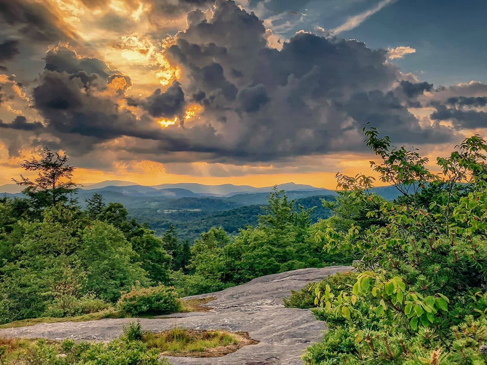
A high-elevation out-and-back hike from the Flat Laurel Creek trailhead on Hwy 215, climbing past two waterfalls to Sam’s Knob (6,050 ft) for sweeping 360-degree mountain and valley views. Led by WNC Sierra Club with a roadless area conservation angle.
A high-elevation out-and-back hike from the Flat Laurel Creek trailhead on Hwy 215, climbing past two waterfalls to Sam’s Knob (6,050 ft) for sweeping 360-degree mountain and valley views. Led by WNC Sierra Club with a roadless area conservation angle.
A high-elevation out-and-back hike from the Flat Laurel Creek trailhead on Hwy 215, climbing past two waterfalls to Sam’s Knob (6,050 ft) for sweeping 360-degree mountain and valley views. Led by WNC Sierra Club with a roadless area conservation angle.
A rugged monster cross gravel cycling challenge winding through Pisgah National Forest on punchy climbs and fast dirt descents. Riders tackle an endurance-style course with a competitive atmosphere and strong local bike-community energy.
A rugged monster cross gravel cycling challenge winding through Pisgah National Forest on punchy climbs and fast dirt descents. Riders tackle an endurance-style course with a competitive atmosphere and strong local bike-community energy.
A rugged monster cross gravel cycling challenge winding through Pisgah National Forest on punchy climbs and fast dirt descents. Riders tackle an endurance-style course with a competitive atmosphere and strong local bike-community energy.
An easy paced guided walk around Lake Junaluska with scenic water views and a relaxed, social group pace. Ideal for visitors wanting a low key outdoor outing and local nature orientation.
An easy paced guided walk around Lake Junaluska with scenic water views and a relaxed, social group pace. Ideal for visitors wanting a low key outdoor outing and local nature orientation.
An easy paced guided walk around Lake Junaluska with scenic water views and a relaxed, social group pace. Ideal for visitors wanting a low key outdoor outing and local nature orientation.
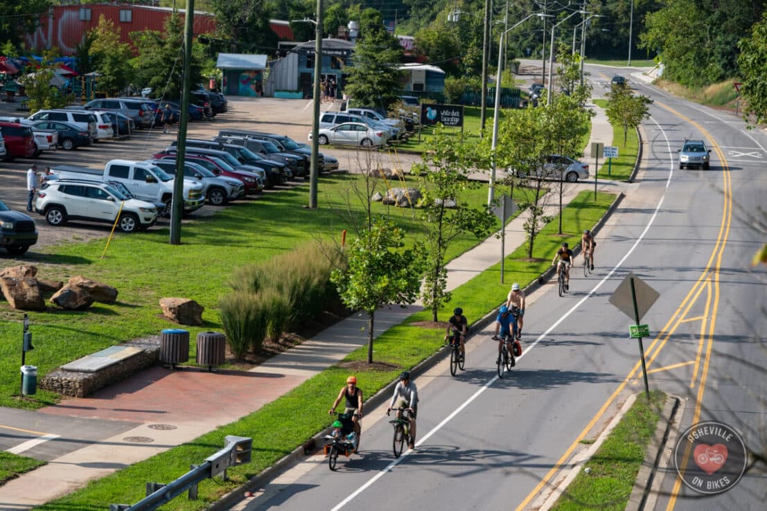
Easy pace group ride through Asheville neighborhoods ending at a local cafe for coffee; Asheville on Bikes hosts a social, all levels bike meetup focused on community connection and casual conversation.
Easy pace group ride through Asheville neighborhoods ending at a local cafe for coffee; Asheville on Bikes hosts a social, all levels bike meetup focused on community connection and casual conversation.
Easy pace group ride through Asheville neighborhoods ending at a local cafe for coffee; Asheville on Bikes hosts a social, all levels bike meetup focused on community connection and casual conversation.
Pedal friendly Monday morning group ride of 10 to 14 miles with roughly 1,000 feet of climbing, coffee start and doughnut finish; no-drop pace and optional Google Meet attendance.
Pedal friendly Monday morning group ride of 10 to 14 miles with roughly 1,000 feet of climbing, coffee start and doughnut finish; no-drop pace and optional Google Meet attendance.
Pedal friendly Monday morning group ride of 10 to 14 miles with roughly 1,000 feet of climbing, coffee start and doughnut finish; no-drop pace and optional Google Meet attendance.

Trail talk on Western North Carolina’s lesser known hiking gems, with tips on finding quieter recreation spots and the benefits of spreading out outdoor use. Presented by Carolina Mountain Club and Sierra Club outings leaders, in person and on Zoom.
Trail talk on Western North Carolina’s lesser known hiking gems, with tips on finding quieter recreation spots and the benefits of spreading out outdoor use. Presented by Carolina Mountain Club and Sierra Club outings leaders, in person and on Zoom.
Trail talk on Western North Carolina’s lesser known hiking gems, with tips on finding quieter recreation spots and the benefits of spreading out outdoor use. Presented by Carolina Mountain Club and Sierra Club outings leaders, in person and on Zoom.
Endurance mountain bike race through Pisgah National Forest near Old Fort, tackling rugged singletrack climbs and fast descents. A rider-focused community event with competitive pacing and backcountry trail conditions.
Endurance mountain bike race through Pisgah National Forest near Old Fort, tackling rugged singletrack climbs and fast descents. A rider-focused community event with competitive pacing and backcountry trail conditions.
Endurance mountain bike race through Pisgah National Forest near Old Fort, tackling rugged singletrack climbs and fast descents. A rider-focused community event with competitive pacing and backcountry trail conditions.